Very Wet - cool first half to the month, then milder and unsettled
The first week of March saw a continuation of Februaries pattern of anticyclonic conditions that resulted in very little rainfall with cool days, although no frost. A 'Blocking High' was situated to the east of Greenland, ridging strongly over the UK. Colder air flooded in from the north behind an area of low pressure on the 6th to bring a run of frosts and some snow. During this period the lowest March minimum for this site was recorded.
An Atlantic 'Low' brought a couple of very wet and mild days 12-13th (especially wet in the LDNP with over 100mm recorded at Honister on the 12th) before a return to wintry conditions, 14-15th, as low pressure to the north pushed south bringing some snow and another very cold night.
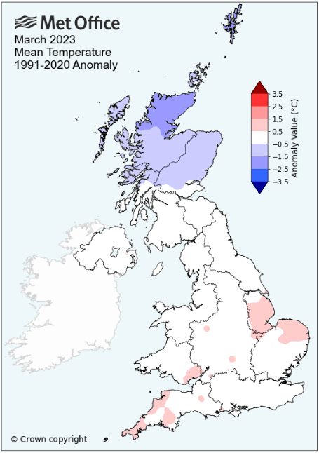
The second half of the month saw a complete reversal as a succession of low pressure systems arrived from off the Atlantic bringing much milder conditions with the majority of days above or at least close to 10°c. However, the second half of the month was more typified by its rainfall and by the month's end precipitation had fallen on every day from the 11th. The days were all rather grey and wet with sunshine at a premium, the 27th being the only exception. Ultimately the mildness of the second half just failed to counter balance the cold first half, although the mean minimum temperature for the month actually finished above average - the disparity coming from the suppressed day-time maximum temperatures and March also finished colder than February.
High pressure (HP) sat between Scotland and Iceland was firmly in charge at the start of the month, with a continuation of Februaries dry weather lasting well into the month; the first ten days of the month seeing just 4.6 mm of precipitation.
On the 5th that HP did start to weaken with a cold front north of Scotland slowly moving south. Then with a weak area of low pressure (LP) moving into the North Sea and continuing east on the 6th saw a much colder Arctic airflow introduced. Up to this point, apart from being dry, the days had been chillyish, but not cold.
Those fronts on the 5-6th only gave a very small amount of rainfall with a little hail on the 6th, but now the 7th would see the first of a run of five air frosts. Overnight into the 8th the pressure gradient completely slackened and with only a little high cloud the temperature plummeted to a new record low of -8.0°c (17.6°f) for March at this site.
Now there was a pool of cold air over the UK, but with an area of LP to the SW that would track along the English Channel, the fronts of which ventured just far enough north to bring us a period of snow late afternoon and through the evening. The maximum temperature would just be 1.7°c and come the morning of the 10th we were left with a snow cover of 3cms, but which would quickly melt.
With a slack pressure gradient and then HP ridging in from N. Europe, it remained chilly on the 11th, but LP from the Atlantic brought milder conditions 12-13th and with it the first meaningful rainfall for since early January. Rain arrived at 15h on the 12th and stayed with us for the rest of the day and throughout the 13th, with a fall of 27.7 mm credited to the 12th. The 12th was also the first day of the month to attain 10°c and it remained very mild overnight into the 13th, but apart from the heavy rainfall it also became very windy with gusts to 54 Mph during the early hours.
The 12th was especially wet in the LDNP with both Honister (118.6 mm) and Seathwaite (108.0 mm) recording well over 4 inches of rain in the 24Hrs.
As the LP cleared NE during the 13th it saw winds back to NW'ly and the 14th was a much colder day especially behind a cold front that pushed south over the UK. This saw a couple of spells of snow during the day, the first either side of mid-day giving a cover that then melted in the afternoon sunshine, but the fall at 16h brought another cover and with temperatures plummeting to -6.0°c overnight, that 2cm cover was still in place for another 'day of lying snow' to be recorded on the 15th.
That snow would quickly melt and now the cold and wintry nature that had marked the first half of the month had drawn to a close and the weather would now be dominated by a series of Atlantic lows that would bring unsettled, mild and wet weather.
After a fall of 12.8 mm on the 16th, the daily totals weren't notable for the next few days, but during the 20-24th a large area of LP would sit virtually static out in the Atlantic and dominate. This LP kept the frontal systems coming and this saw totals of 15.6 mm (21st), 29.8 mm (22nd) and 9.0 mm (23rd) and along with the rain it was often windy. During this period it was also rather mild, both by day and night. Day-time maxima were very slightly above 10°c with night-time minima over 5°c.
On the 24th the LP started a journey east and by the 26th it had moved through which now allowed for a NE'ly flow behind it. The 25-26th saw the occasional shower and at 6.9°c it was that bit chillier on the 26th.
A ridge of HP on the 27th that sat over the UK brought a gloriously sunny day on the 27th and with it a pair of air frosts 27-28th, but this was untypical for the second half of the month.
However, the month would now see a return of the unsettled and mild conditions fed by LP systems from the Atlantic. Indeed the cloud arrived in the early hours of the 28th, curtailing the frost in its tracks and then whilst the day may not have finished with a high rainfall total (5.2 mm), it was grey and drizzly.
The 29th then followed suit with rain or drizzle all day, but it was the mildness of the last three days that stood out, comfortably into double figures and with overnight minima above 5°c, the 8.4°c on the 30th being especially high.
MSLP of 1006.1 Mb was -9.1 MB below average for the month and overall a mean minimum of 2.12°c and a mean maximum of 8.55°c saw the temperature 0.18°c below the fourteen year average for this site.
It was the coldest March since 2018 and since the record began (in 2009), nine have been warmer and five colder - the highest maximum temperature recorded during the month being 13.4°c (17th), the lowest minimum -8.0°c (8th).
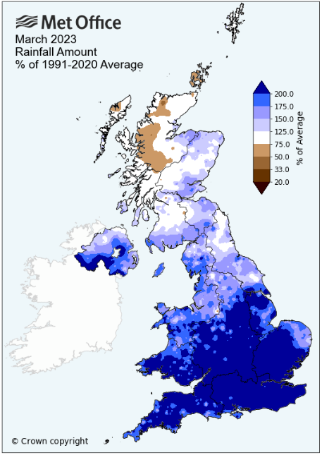
Rainfall of 150.3 mm (Maulds Meaburn North 149.7 mm -- Castlehowe Scar 204.0 mm) was 172.8% of average for 2008-22, making it the wettest March since 2021. In a record that commenced in 2008, 13 have been drier and two have been wetter.
During the month the following 'days of' were recorded: Snowfall on four Days -- Snow Laying on two days -- Hail on two days - the wind speed averaged 7.19 mph, with a maximum gust of 54 mph (13th).
We had 11 Air Frosts in the month (year 25) -- Grass Frosts totalled 14 (year 43).
The 1 foot soil temp ranged from a low of 3.8°c on the 9th to a high of 8.8°c on the 31st -- with a monthly mean of 6.5°c
The 1 meter soil temp ranged from a low of 6.1°c on the 13th to a high of 7.9°c on the 27th -- with a monthly mean of 7.0°c
At the Met' Office site at Shap a mean minimum of 1.1°c and a mean maximum of 7.7°c saw the monthly mean temperature 0.25°c below average. It was the coldest March since 2018. In a record back to 1992 (one year with no data) twenty have been warmer and ten colder.
Rainfall of 264.2 mm represents 187.1% of its average. It was the wettest March since 2021 and in a record that commenced in 1989, thirty have been drier and four have been wetter.
At Appleby in Westmorland rainfall of 106.1 mm represents 174.5% of its average (1857-2022) and made it the wettest since 2021 - in a record that commenced in 1857, 148 have been drier and 18 have been wetter.
Cumbria Rainfall - .
Even at Seathwaite the first ten days of the month only saw rain on three days, with a total of 9.0 mm ... to then finish with a monthly total of 545.0 mm demonstrates the complete turnabout in the month's weather after this point.
The dryness at the start of the month was a continuation of the weather experienced in February and in many ways March was: 'Like January, but in reverse'.
The break-down in the weather was also dramatic. The 12th saw both Honister (118.6 mm) and Seathwaite record a daily fall in excess of 100mm and fairly broadly, but not exclusively, this was the month's wettest day across the county. At some sites in the eastern portion of the county the 22nd was just that little wetter than the 12th.
With 572.6 mm (22.54") Honister may have had the greatest total fall for the month, aided by that fall on the 12th and a further nine days when over an inch fell (four days in total exceeded 50mm) and whilst a number of sites within the LDNP finished with over 200% of their LTA, Barrow (Palace Nook) (157.5 mm -- 230.9%) finished with the greatest percentage fall.
Either side of Carlisle (east and west), Cumwhinton (65.2 mm) and Thursby (68.0 mm) finished with relatively small totals, but that 68.0 mm at Thursby actually represents 121.9% of its LTA and wasn't even the lowest percentage fall in the county!
The Oasis Village at Whinfell, to the east of Penrith finished with a percentage that actually made it ... drier than average! It's monthly total of 97.6 mm representing 98.7% of its LTA – quite remarkable as just a very few short miles along the A66 Kirkby Thore with a fall of 81.0 mm recorded 160.4% of its LTA.
More broadly, the south, south-west (inc coastal) and parts of the LDNP experienced the greatest percentage falls this month; the percentages decreasing in the northern part of the county (except Sebergham – 222.6%) and in the north-east.
Whilst the 26th was a dry day at many locations and broke a continuous run of 'rain days' back to the 11th, this wasn't the case everywhere and ultimately rain was recorded every day of the month from the 11th.
Figures from the Environment Agency's rainfall sites were, (figure in brackets being the monthly average for 1991-2020) 'Data kindly provided by the Hydrometry and Telemetry team of the Environment Agency (Penrith)':
Kirkby Thore 81.0 mm -- (50.5 mm)
Haresceugh Castle (Kirkoswald) 91.11 mm -- (71.5 mm)
Brothers Water 399.7 mm -- (213.2 mm)
Orton (Shallowford) 250.4 mm -- (131.5 mm [average for 1967-2022]) - making it the wettest since 2020 and since 1967 when the record commenced, 49 have been drier and seven have been wetter.
Seathwaite Farm (Borrowdale) 545.0 mm -- (260.4 mm [average for 1845-2022]) - making it the wettest since 2021 and since 1845 when the record commenced, 170 have been drier and 8 have been wetter.
JANUARY 2010
FEBRUARY 2010
MARCH 2010
APRIL 2010
MAY 2010
JUNE 2010
JULY 2010
AUGUST 2010
SEPTEMBER 2010
OCTOBER 2010
NOVEMBER 2010
DECEMBER 2010
JANUARY 2011
FEBRUARY 2011
MARCH 2011
APRIL 2011
MAY 2011
JUNE 2011
JULY 2011
AUGUST 2011
SEPTEMBER 2011
OCTOBER 2011
NOVEMBER 2011
DECEMBER 2011
JANUARY 2012
FEBRUARY 2012
MARCH 2012
APRIL 2012
MAY 2012
JUNE 2012
JULY 2012
AUGUST 2012
SEPTEMBER 2012
OCTOBER 2012
NOVEMBER 2012
DECEMBER 2012
SUMMER 2012
REVIEW OF 2012
JANUARY 2013
FEBRUARY 2013
MARCH 2013
APRIL 2013
MAY 2013
JUNE 2013
JULY 2013
AUGUST 2013
SEPTEMBER 2013
OCTOBER 2013
NOVEMBER 2013
DECEMBER 2013
REVIEW OF 2013
JANUARY 2014
FEBRUARY 2014
MARCH 2014
APRIL 2014
MAY 2014
JUNE 2014
JULY 2014
AUGUST 2014
SEPTEMBER 2014
OCTOBER 2014
NOVEMBER 2014
DECEMBER 2014
WINTER 2014
REVIEW OF 2014
JANUARY 2015
FEBRUARY 2015
MARCH 2015
APRIL 2015
MAY 2015
JUNE 2015
JULY 2015
AUGUST 2015
SEPTEMBER 2015
OCTOBER 2015
NOVEMBER 2015
DECEMBER 2015
REVIEW OF 2015
JANUARY 2016
FEBRUARY 2016
MARCH 2016
APRIL 2016
MAY 2016
JUNE 2016
JULY 2016
AUGUST 2016
SEPTEMBER 2016
OCTOBER 2016
NOVEMBER 2016
DECEMBER 2016
REVIEW OF 2016
JANUARY 2017
FEBRUARY 2017
MARCH 2017
APRIL 2017
MAY 2017
JUNE 2017
JULY 2017
AUGUST 2017
SEPTEMBER 2017
OCTOBER 2017
NOVEMBER 2017
DECEMBER 2017
REVIEW OF 2017
JANUARY 2018
FEBRUARY 2018
MARCH 2018
APRIL 2018
MAY 2018
JUNE 2018
JULY 2018
AUGUST 2018
SEPTEMBER 2018
OCTOBER 2018
NOVEMBER 2018
DECEMBER 2018
REVIEW OF 2018
JANUARY 2019
FEBRUARY 2019
MARCH 2019
APRIL 2019
MAY 2019
JUNE 2019
JULY 2019
AUGUST 2019
SEPTEMBER 2019
OCTOBER 2019
NOVEMBER 2019
DECEMBER 2019
REVIEW OF 2019
JANUARY 2020
FEBRUARY 2020
MARCH 2020
APRIL 2020
MAY 2020
JUNE 2020
JULY 2020
AUGUST 2020
SEPTEMBER 2020
OCTOBER 2020
NOVEMBER 2020
DECEMBER 2020
REVIEW OF 2020
JANUARY 2021
FEBRUARY 2021
MARCH 2021
APRIL 2021
MAY 2021
JUNE 2021
JULY 2021
AUGUST 2021
SEPTEMBER 2021
OCTOBER 2021
NOVEMBER 2021
DECEMBER 2021
REVIEW OF 2021
JANUARY 2022
FEBRUARY 2022
MARCH 2022
APRIL 2022
MAY 2022
JUNE 2022
JULY 2022
AUGUST 2022
SEPTEMBER 2022
OCTOBER 2022
NOVEMBER 2022
DECEMBER 2022
REVIEW OF 2022
OTHER ARTICLES
The Oldest Inhabitant
An Inch Of Scotch Mist
But it's meant to be Summer (Summer 2017)
© Darren Rogers 2010-23
Want to comment on this site? email